We're about 50+ hours from the eye of Rita making landfall somewhere near Galveston on Saturday morning, but hurricane force winds will start hitting sometime Friday night. It's currently a Category 5 storm with 175 mph winds, the third strongest strongest hurricane (in terms of pressure) ever recorded, just ahead of Katrina, but wind speeds should be somewhat lower when it hits land (whether it'll be a Cat 4 or a Cat 3 then depends on the model used, but there's still a distinct possibility it'll still be Cat 5 when it hits Galveston -- which sits on a barrier island and which, of course, was completely wiped out by the Hurricane of 1900, with at least 6,000 people killed.
When Katrina was about 52 hours from landfall, the official National Hurricane center forecast track was substantially correct about where it would make landfall, and six hours later they had it precisely right -- so, at least from that record, it looks like Galveston landfall would be a good bet.
And right behind Galveston, 50 miles inland, is Houston, with its history of flooding problems.
(Thurs 1:45am): How vulnerable is Galveston?
By the reckoning of public officials who safeguard the island, Galveston residents would have only one defense from a storm like Katrina: evacuation. Such a storm, said Eliot Jennings, Galveston County's emergency management coordinator, would do a "whole lot of damage."
The island city's mayor, Lyda Ann Thomas, went further.
"I think the island would be destroyed, wiped out," she said. "There wouldn't be anything left. I do think Galvestonians are paying attention to what happened, and people who thought they might not evacuate will now think twice before they decide whether to leave the island."
While New Orleans counted on its levee system, Galveston's sense of security comes from a 15-foot wall. After the great storm of 1900, which killed 8,000, Galveston's leaders constructed a seawall along much of the island's eastern end. They also raised the city directly behind it from a peak of 8 feet above sea level to about 15 feet.
The island now reaches its highest point at the seawall, gently sloping back to sea level at bayside.
A Katrina-size storm would not destroy the seawall, and indeed the wall would absorb much energy from the biggest, crashing waves. But Katrina's storm surge crested at 22 feet, enough height to easily clear the seawall. And the city has no protection from bayside waters.
"The island would be completely underwater," said Donald Van Nieuwenhuise, director of petroleum geoscience programs at UH. "And it's less protected from winds than New Orleans. The only good thing is that, once the rain and winds went away, water would begin to recede." [Houston Chronicle (9/8/2005)]
(Thurs 2:00am): Although New Orleans is out of the path of the storm, the current NHC advisory is calling for it to receive 2- 4 inches of rain. The Army Corps of Engineers says that the city can handle 6 inches, and storm surge of 10-12 feet.
(Thurs 5:00am): I begin with the tradition disclaimer: IANAM (I am not a meterologist). From what I understand, the raw fuel that powers the hurricane engine is warm water. Now, Rita just grew from a Category 1 storm to a Category 5 in what seemed like an incredibly short time -- and yet, from the evidence of the map below, it seems as if it's just about to move into an area where the sea surface temperatures are even warmer (if only by a degree):
[Important note: The image you see below is not the image that I originally posted here on 9/22. The image connected to this URL is updated regularly, and I have been unable to locate where the images are archived so that I can fix the URL to point to the correct image. I'm leaving this here so that you can see at least the type of image I was referring to. For other images related to sea surface temperature, see further below in this post. -- Ed (10/17/05)]
It also looks like the water just off the coast of Texas is warmer still. I'm not doubting the forecast at all, just wondering what other factors are inhibiting the growth of the storm if water temperature continues to feed it.
(Note that I write this with full understanding that a little knowledge can be a dangerous thing.)
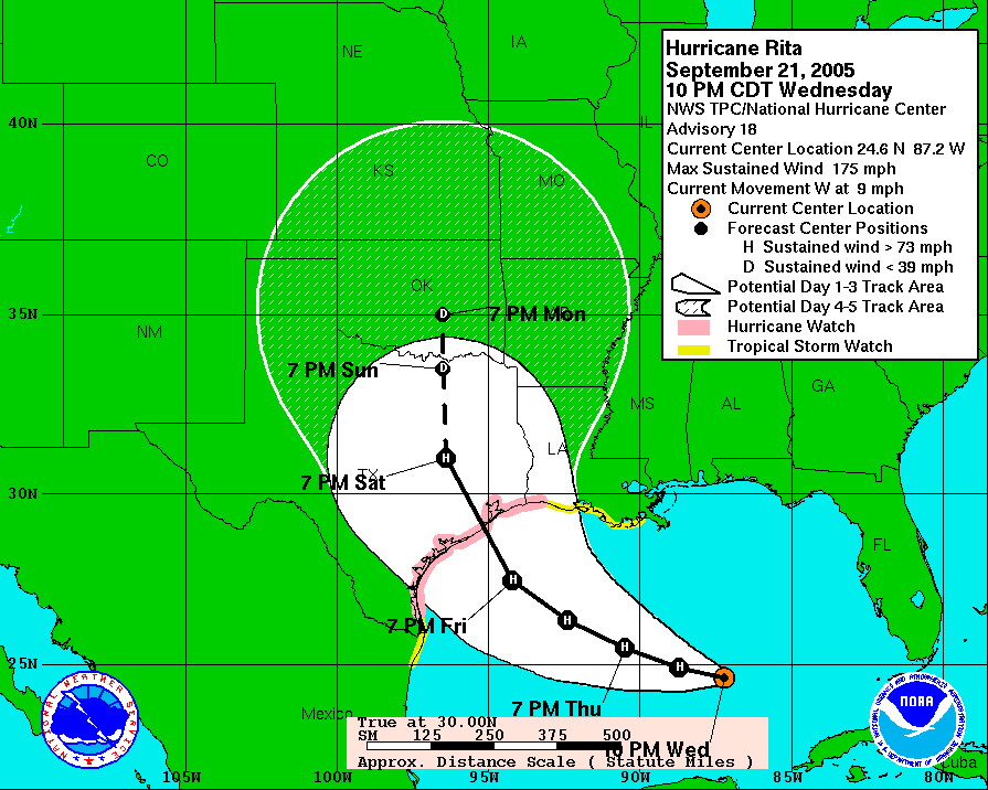
(Thurs 5:30am): And continuing to reveal my ignorance, I note that as of the 4am (central) advisory the NHC has given up saying that Rita is going to pick up speed. It had been moving at 13 - 14 mph, but then slowed down to 9 mph, and they kept expecting it to pick up again. Now, they're saying that it will keep the slower speed for the next 24 hours.
I assume this slowdown means that there's a chance it will hit farther to the north and east then was expected, and a little later as well. The current NHC Discussion seems to verify at least part of that:
THE TRACK GUIDANCE IS NOW CLUSTERED AROUND A LANDFALL BETWEEN THE SABINE RIVER AND MATAGORDA TEXAS IN 48-60 HR ... WITH A NET EASTWARD SHIFT OF THE GUIDANCE SINCE THE LAST PACKAGE. THE NEW FORECAST TRACK IS ALSO SHIFTED EASTWARD ABOUT 30 N MI ... CALLING FOR LANDFALL NEAR THE BOLIVAR PENINSULA AND GALVESTON BAY.
("Track guidance" means, I think, the computer models that you can see here, or in by the second map in the "Rita Watch" sidebar.)
I believe this new forecast landfall means that the storm would go to the right of Galveston instead of the left, putting on the "cleaner" side of the storm, with (I believe) less of a storm surge.
I note that the new track forecast has put New Orleans a little closer to the penumbra of the 5-day cone, which is worrisome. I was concerned about the storm hitting the city from the Gulf, and it looks like it won't do that, but I failed to consider the possbility that it mght take a right turn after hitting the Texas coast and pass over New Orleans that way. Of course if it does, I suppose it will be a less intense storm, but still...
As for the question I asked above, about the water temperature in the Gulf determining intensity, here's what the NHC says about the storm's intensity:
THE INTENSITY FORECAST REMAINS SOMEWHAT PROBLEMATIC. FIRST ... THE MORE NORTHERLY TRACK WILL LIKELY KEEP RITA OVER THE LOOP CURRENT LONGER THAN PREVIOUSLY EXPECTED ... SO THE EFFECT OF LOWER OCEAN HEAT CONTENT MAY BE SOMEWHAT LESS THAN PREVIOUSLY EXPECTED IN THE FIRST 24 HR OR SO. SECOND ... THE GFS AND SHIP MODELS FORECAST SIGNIFICANT SHEAR OVER RITA AFTER 24 HR ... WHICH RESULTS IN SHIPS CALLING FOR SIGNIFICANT WEAKENING. SHEAR ANALYSES FROM CIMSS AT THE UNIVERSITY OF WISCONSIN SHOW ABOUT 12 KT OF SOUTHERLY SHEAR CAUSED BY AN UPPER-LEVEL ANTICYCLONE EAST OF RITA ... AND THE LARGE-SCALE MODELS SUGGEST THIS PATTERN WILL CONTINUE UNTIL LANDFALL. HOWEVER ... THE GFS AND SHIPS MAY BE OVERDOING THE SHEAR. FINALLY ... THERE WILL BE AT LEAST ONE AND POSSIBLE MORE CONCENTRIC EYEWALL CYCLES BEFORE LANDFALL. THE INTENSITY FORECAST IS BASED ON THE PREMISE THAT SHEAR AND REDUCED OUTFLOW WILL CAUSE A GRADUAL WEAKENING ... ESPECIALLY AFTER RITA MOVES WEST OF THE LOOP CURRENT IN 24-36 HR. SUPERIMPOSED ON TOP OF THIS WILL BE FLUCTUATIONS CAUSED BY CONCENTRIC EYEWALL CYCLES. THE NEW INTENSITY FORECAST IS AN UPDATE OF THE PREVIOUS FORECAST...CALLING FOR SLOW OVERALL WEAKENING BUT NOT AS MUCH AS SHOWN BY SHIPS.
Since I understood about 1% of that, I should probably keep my thoughts to myself. Obviously, the intensity of the storm is complexly determined.
(Thurs 3:30pm): The computer models have shifted landfall to the east. Three still show it near Galveston, but one has it at the Texas/Louisiana border, and the fifth has it in western Louisiana. I'd expect the NHC official forecast track to move its landfall position eastwards as well in the next advisory, probably to the border, putting the storm closer to New Orleans. NOLA is now in the 5-10% band for experiencing hurricane force winds, the first time that's happened for this storm -- and its chance of getting tropical force winds is about 50%. (For the rest of the Katrina-damaged Gulf Coast, the chances are between 2%0 and 40%.)
So, despite my relief last night, it seems as if New Orleans is not out of the woods.
(Thurs 5:45pm): Further on the possibility of the storm strengthening because of high water temperatures:
RITA IS CURRENTLY MOVING OVER THE EDGE OF A COLD SST EDDY. THIS COULD HAVE ENHANCED THE WEAKENING TODAY. THE HURRICANE IS FORECAST TO MOVE OVER ANOTHER WARM EDDY DURING THE NEXT 12 TO 24 HOURS AND THERE IS SOME CHANCE THAT RITA COULD REGAIN SOME INTENSITY. BECAUSE THE SHEAR IS FORECAST TO INCREASE ... THIS MAY COMPENSATE FOR THE STRENGTHENING THAT MAY BE CAUSED BY THE EFFECTS OF THE HIGH HEAT CONTENT.
So wind shear is the countervailing force that I was looking for which counters the effect of warmer water.
New Orleans is now under a Tropical Storm Warning, but
ANY TROPICAL STORM FORCE WINDS IN THE NEW ORLEANS AREA ARE EXPECTED TO BE CONFINED TO A FEW SQUALLS ASSOCIATED WITH QUICKLY MOVING RAINBANDS
which is good news. I saw a piece on CNN in which the Corps of Engineers was quoted as saying that the flood control system there in its current state can only deal with 3 inches of rain, but
RAINFALL AMOUNTS OF 3 TO 5 INCHES ARE POSSIBLE OVER SOUTHEASTERN LOUISIANA INCLUDING NEW ORLEANS
and
TIDES ARE CURRENTLY RUNNING ABOUT 2 FEET ABOVE NORMAL ALONG THE LOUISIANA ... MISSISSIPPI AND ALABAMA COASTS IN THE AREAS AFFECTED BY KATRINA. TIDES IN THOSE AREAS WILL INCREASE TO 3 TO 5 FEET AND BE ACCOMPANIED BY LARGE WAVES
So it seems clear that things could get bad in Katrina-land at the same time that Rita makes new devastation.
(Thurs 9:15pm): Uh-oh, one of the computer tracking models (GFS) shows Rita hitting the coast between Galveston and the Louisiana border, and then looping around to the right and hanging out for a while near Baton Rouge. I'll have to wait for the 11pm NHC discussion to see if they explain what that's about. I'm also still looking for them to move the forecast landfall farther east (it's currently about two-thirds of the way from Galveston to Port Arthur [population 58,000], in an area that looks like it doesn't have much in it in the way of population or industry).
The more I think about it, this might be among the better places for Rita to come ashore, if it wasn't going to go to the "dead zone" between Corpus Christi and Brownsville. Going to the west of Galveston and Houston is best for those cities, putting them on the better side of the storm, and it might be far enough away from New Orleans, Biloxi and Gulfport so that they don't get kneed in the groin again.
(Thurs 10:45pm): I neglected to mention that while one model (GFS [AVN]) has Rita turning to the right after landfall, two of the others (BAM Medium and NOGAPS) have it turning to the left, so there's substantial disagreement between the models about what will happen once the storm comes ashore.
Also, the CNN meterologist just pointed at a change in the storm's direction, to the west. If it's just a temporary wobble, that's one thing, but if it's a permanent change, that might put landfall once again closer to Galveston/Houston -- so there still seems to be a fair amount of uncertainty about Rita's track.
Oh, let me mention here again how annoying I find the impulse to over-anthropomorphize the storm. Headline writers, both print and in the electronic media, are most prone to this. Storms have "fury," "wrath," and so on, which is entirely untrue. A hurricane is a natural process of the earth's weather, it has no emotions or intentions, it just goes where it's determined to go by the forces which created it and control it. When it gets there, it causes damage, but the damage is made possible by the actions of men and women, who build communities on barrier islands, or below sea level, or who try to control river flooding and as a result destroy wetlands which suck up a storm's power. It's people who pump out the water from the aquifers and cause the land to subside, making it prone to flooding, or who suck up oil with offshore rigs and refine it into substances that make things go.
None of that has anything to do with the storm itself, it just goes where it goes, we've put ourselves in harm's way -- and then blame the storm.
(Thurs 11:15pm): It looks like the NHC didn't move their landfall very far. I don't have the mapping software to be absolutely certain, but it looks as if it moved a but eastward, closer to Port Arthur, which now has the distinction of being the major community lying on the stronger side of the storm (the right front, or the northeast quadrant in this case). [Note: I was wrong about the projected landfall moving to the east -- when they published the most recent Discussion, it indicated that no change had been made to the project track.]
On CNN, Max Mayfield of the NHC just said that the shift in the storm's track is just a "wobble" and not significant.
(Fri Sept 23 12:15am): Here's another interesting image:
If I understand correctly, sea surface height is an indication of how much warm water is stored below the surface -- so the dark red bubble in the northwest Gulf is a much warmer patch of water. It is this, I think, that Rita is about to pass through, and which may cause it to intensify once more, if the intensity is not held back by increasing wind shear.
(Fri 12:30am) This is interesting -- after landfall
RITA IS FORECAST TO THEN ESSENTIALLY STALL IN ABOUT THREE DAYS IN THE AREA OF NORTHEASTERN TEXAS WHERE STEERING CURRENTS ARE FORECAST TO BECOME VERY WEAK. THIS SCENARIO POSES A GREAT RISK OF VERY HEAVY RAINFALL WELL INLAND AND FOR MANY DAYS AFTER LANDFALL.
So, depending on where it stalls, there may be flooding problems pretty far inland, or in the flood plains of the rivers that drain those areas.
(Fri 2:45am): There's some concern that once Rita makes landfall and moves inland, it could stall over northeastern Texas and dump perhaps 30 inches of rain there. It's happened before:
One of the state's worst floods in recent memory occurred June 30, 2002, when a massive storm system stalled over South Texas for eight days. More than 35 inches of rain fell.
Runoff from the storms caused record flooding downstream on the Medina, San Antonio, Sabinal and Nueces rivers. For the first time since it filled in 1968, Canyon Lake near New Braunfels poured over its spillway, adding to the flooding in the Guadalupe River. Residents along the Guadalupe in Cuero and Victoria suffered extensive damage as the river rose out of its banks for several miles.
Twelve people died in the storm, and more than 48,000 homes were destroyed in 80 Texas counties. Total damage was estimated at more than $1 billion.
The destruction Rita will cause depends on where the storm lands and how it moves inland – whether it quickly dissipates or stalls over South Central Texas like the 2002 storm.
"Wherever Rita lands, the east side of the storm will get more rain and more risk of flooding," said Robert Blodgett, a geologist at Austin Community College.
"Fortunately, much of Central Texas is dry, and the ground can soak up a lot of excess moisture. If the storm dumps a lot of rain very quickly, however, it could produce flash flooding along stream beds and paved areas, such as urban streets and parking lots." [Dallas Morning News]
So that would be the Texas Trifecta for Rita: wash out Galeveston, swamp Houston, and deluge Dallas. Fortunately, it still looks like it'll pass to the east of Galveston/Houston (sorry, Port Arthur), but the NHC people interviewed on TV are being cagey about this one, they keep talking about how it could shift at any time.
(Fri 5:45am): Here's an image I've been looking for since seeing it on CNN. It's basically the same image as above, but with Rita's track superimposed, and contour lines indicated the temperature gradient:
This sea surface height map of the Gulf of Mexico, with the Florida peninsula on the right and the Texas-Mexico Gulf Coast on the left, is based on altimeter data from four satellites including NASA’s Topex/Poseidon and Jason. Red indicates a strong circulation of much warmer waters, which can feed energy to a hurricane. This area stands 35 to 60 centimeters (about 13 to 23 inches) higher than the surrounding waters of the Gulf. The actual track of a hurricane is primarily dependent upon steering winds, which are forecasted through the use of atmospheric models. However, the interaction of the hurricane with the upper ocean is the primary source of energy for the storm. Hurricane intensity is therefore greatly affected by the upper ocean temperature structure and can exhibit explosive growth over warm ocean currents and eddies. Eddies are currents of water that run contrary to the direction of the main current. According to the forecasted track through the Gulf of Mexico, Hurricane Rita will continue crossing the warm waters of a Gulf of Mexico circulation feature called the Loop Current and then pass near a warm-water eddy called the Eddy Vortex, located in the north central Gulf, south of Louisiana. [More here.]
Image: NASA/JPL/University of Colorado
(Fri 10:00am): It should be noted that despite having the advantage of the object lesson of what happened in New Orleans with Katrina, the authorities in Texas haven't done all that well so far. They did put together an evacuation plan, but, judging from the evidence of the massive traffic jams, the implementation of it was clearly less than ideal.
I wonder if the people who were so quick to jump down the back of the Lousiana and New Orleans authorities are going to be as willing to criticize the authorities in Texas and Houston?
They shouldn't because, in my opinion, both criticisms are unfair. The job FEMA has to do -- organize and bring in relief -- is massive and complex, but at least many of the people they deal with are professionals, military personnel or highly trained civilians, many of them volunteers who actively want to be where they going and to do whata they're doing. Local authorities have a completely different kind of person to deal with: ordinary citizens who don't want to evacuate, aren't trained in what to do to evacuate, and are generally annoyed or pissed off that they've been forced to interrupt their normal lives. Dealing with massive numbers of that kind of person (at once essentially random, like the movement of molecules in a gas or the flow of a liqud, and at the same time strongly willful and demanding) is a lot more difficult and problematic than dealing with FEMA's professionals, soldiers and volunteers.
That's why when FMEA screwed up, it was a major thing, and they, and Bush, received only the criticism they deserved, whereas the criticism of the local authorities was overblown (and n large part highly partisan), because it didn't take into account the much harder circumstances and conditons they labored under.
So, just as I was willing to give Nagin and Blanco a break, so I'm not jumping down the throat of Governor Perry of Texas or Mayor Bill White of Houston.
Still, there's no denying that the evacuation could be going more smoothly.
(Fri 10:15am): I'm closing this post out, and will continue to post about Hurricane Rita and its aftermath at Rita comes ashore.
absolutist
aggresive
anti-Constitutional
anti-intellectual
arrogant
authoritarian
blame-placers
blameworthy
blinkered
buckpassers
calculating
class warriors
clueless
compassionless
con artists
conniving
conscienceless
conspiratorial
corrupt
craven
criminal
crooked
culpable
damaging
dangerous
deadly
debased
deceitful
delusional
despotic
destructive
devious
disconnected
dishonorable
dishonest
disingenuous
disrespectful
dogmatic
doomed
fanatical
fantasists
felonious
hateful
heinous
hostile to science
hypocritical
ideologues
ignorant
immoral
incompetent
indifferent
inflexible
insensitive
insincere
irrational
isolated
kleptocratic
lacking in empathy
lacking in public spirit
liars
mendacious
misleading
mistrustful
non-rational
not candid
not "reality-based"
not trustworthy
oblivious
oligarchic
opportunistic
out of control
pernicious
perverse
philistine
plutocratic
prevaricating
propagandists
rapacious
relentless
reprehensible
rigid
scandalous
schemers
selfish
secretive
shameless
sleazy
tricky
unAmerican
uncaring
uncivil
uncompromising
unconstitutional
undemocratic
unethical
unpopular
unprincipled
unrealistic
unreliable
unrepresentative
unscientific
unscrupulous
unsympathetic
venal
vile
virtueless
warmongers
wicked
without integrity
wrong-headed
Thanks to: Breeze, Chuck, Ivan Raikov, Kaiju, Kathy, Roger, Shirley, S.M. Dixon
recently seen
i've got a little list...
Elliott Abrams
Steven Abrams (Kansas BofE)
David Addington
Howard Fieldstead Ahmanson
Roger Ailes (FNC)
John Ashcroft
Bob Bennett
William Bennett
Joe Biden
John Bolton
Alan Bonsell (Dover BofE)
Pat Buchanan
Bill Buckingham (Dover BofE)
George W. Bush
Saxby Chambliss
Bruce Chapman (DI)
Dick Cheney
Lynne Cheney
Richard Cohen
The Coors Family
Ann Coulter
Michael Crichton
Lanny Davis
Tom DeLay
William A. Dembski
James Dobson
Leonard Downie (WaPo)
Dinesh D’Souza
Gregg Easterbrook
Jerry Falwell
Douglas Feith
Arthur Finkelstein
Bill Frist
George Gilder
Newt Gingrich
John Gibson (FNC)
Alberto Gonzalez
Rudolph Giuliani
Sean Hannity
Katherine Harris
Fred Hiatt (WaPo)
Christopher Hitchens
David Horowitz
Don Imus
James F. Inhofe
Jesse Jackson
Philip E. Johnson
Daryn Kagan
Joe Klein
Phil Kline
Ron Klink
William Kristol
Ken Lay
Joe Lieberman
Rush Limbaugh
Trent Lott
Frank Luntz
"American Fundamentalists"
by Joel Pelletier
(click on image for more info)
Chris Matthews
Mitch McConnell
Stephen C. Meyer (DI)
Judith Miller (ex-NYT)
Zell Miller
Tom Monaghan
Sun Myung Moon
Roy Moore
Dick Morris
Rupert Murdoch
Ralph Nader
John Negroponte
Grover Norquist
Robert Novak
Ted Olson
Elspeth Reeve (TNR)
Bill O'Reilly
Martin Peretz (TNR)
Richard Perle
Ramesh Ponnuru
Ralph Reed
Pat Robertson
Karl Rove
Tim Russert
Rick Santorum
Richard Mellon Scaife
Antonin Scalia
Joe Scarborough
Susan Schmidt (WaPo)
Bill Schneider
Al Sharpton
Ron Silver
John Solomon (WaPo)
Margaret Spellings
Kenneth Starr
Randall Terry
Clarence Thomas
Richard Thompson (TMLC)
Donald Trump
Richard Viguere
Donald Wildmon
Paul Wolfowitz
Bob Woodward (WaPo)
John Yoo
guest-blogging
All the fine sites I've
guest-blogged for:
Be sure to visit them all!!
recent listening
influences
John Adams
Laurie Anderson
Aphex Twin
Isaac Asimov
Fred Astaire
J.G. Ballard
The Beatles
Busby Berkeley
John Cage
"Catch-22"
Raymond Chandler
Arthur C. Clarke
Elvis Costello
Richard Dawkins
Daniel C. Dennett
Philip K. Dick
Kevin Drum
Brian Eno
Fela
Firesign Theatre
Eliot Gelwan
William Gibson
Philip Glass
David Gordon
Stephen Jay Gould
Dashiell Hammett
"The Harder They Come"
Robert Heinlein
Joseph Heller
Frank Herbert
Douglas Hofstadter
Bill James
Gene Kelly
Stanley Kubrick
Jefferson Airplane
Ursula K. LeGuin
The Marx Brothers
John McPhee
Harry Partch
Michael C. Penta
Monty Python
Orbital
Michael Powell & Emeric Pressburger
"The Prisoner"
"The Red Shoes"
Steve Reich
Terry Riley
Oliver Sacks
Erik Satie
"Singin' in the Rain"
Stephen Sondheim
The Specials
Morton Subotnick
Talking Heads/David Byrne
Tangerine Dream
Hunter S. Thompson
J.R.R. Tolkien
"2001: A Space Odyssey"
Kurt Vonnegut
Yes
Bullshit, trolling, unthinking knee-jerk dogmatism and the drivel of idiots will be ruthlessly deleted and the posters banned.
Entertaining, interesting, intelligent, informed and informative comments will always be welcome, even when I disagree with them.
I am the sole judge of which of these qualities pertains.
E-mail
All e-mail received is subject to being published on unfutz without identifying names or addresses.
Corrections
I correct typos and other simple errors of grammar, syntax, style and presentation in my posts after the fact without necessarily posting notification of the change.
Substantive textual changes, especially reversals or major corrections, will be noted in an "Update" or a footnote.
Also, illustrations may be added to entries after their initial publication.
the story so far
unfutz: toiling in almost complete obscurity for almost 1500 days
If you read unfutz at least once a week, without fail, your teeth will be whiter and your love life more satisfying.
If you read it daily, I will come to your house, kiss you on the forehead, bathe your feet, and cook pancakes for you, with yummy syrup and everything.
(You might want to keep a watch on me, though, just to avoid the syrup ending up on your feet and the pancakes on your forehead.)
Finally, on a more mundane level, since I don't believe that anyone actually reads this stuff, I make this offer: I'll give five bucks to the first person who contacts me and asks for it -- and, believe me, right now five bucks might as well be five hundred, so this is no trivial offer.


